Weather’s Wild Siblings: Meet El Niño and La Niña
You’ve probably heard their names tossed around in weather reports, El Niño and La Niña. but what exactly are they? Think of them as the ocean’s way of stirring up drama in our global weather. These two natural climate patterns are like siblings who take turns influencing everything from rainfall to hurricanes, leaving meteorologists (and the rest of us) on our toes.
El Niño, the more famous of the two, is like the rowdy older brother. It shows up when the Pacific Ocean near the equator gets unusually warm, shaking up wind and rain patterns worldwide. La Niña, on the other hand, is the cooler, quieter sister. She arrives when those same waters turn colder than usual, bringing her own set of weather surprises. Together, they’re part of a bigger cycle that scientists call the *El Niño-Southern Oscillation* (or ENSO for short).
In this blog, we’ll break down how these two work, why they matter, and what their antics mean for your local weather. No jargon, no confusion, just the basics to help you understand the forces behind those “warmer than average” or “drier than usual” forecasts. Ready to dive in?
What Are El Niño and La Niña?
Imagine the Pacific Ocean as a giant bathtub. Normally, warm water piles up in the western side near Asia, while cooler water stays in the eastern side near the Americas. This balance keeps weather patterns steady. But sometimes, the “bathtub” sloshes in unexpected ways, and that’s where El Niño and La Niña come in.
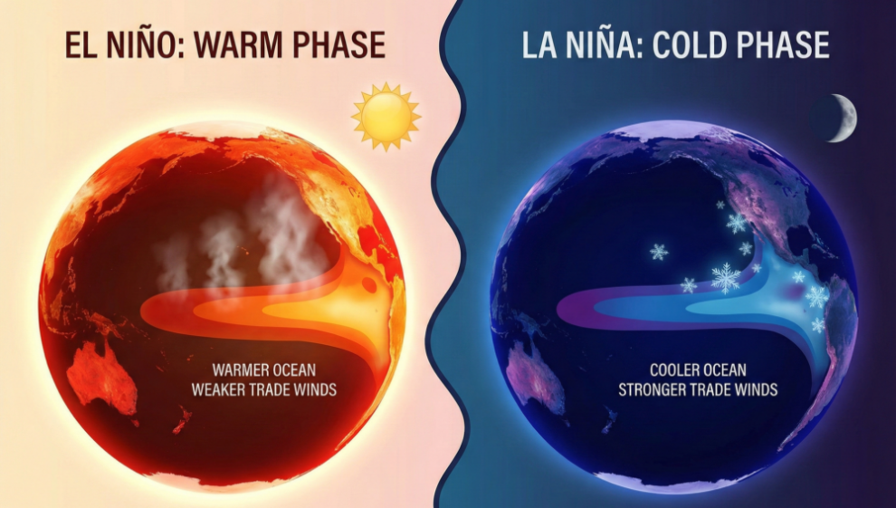
El Niño happens when the warm water spreads eastward, covering the central and eastern Pacific. It’s like turning up the heat in that part of the ocean, which messes with global weather. La Niña is the opposite when the warm water retreats even more to the west, leaving the eastern Pacific colder than usual. These shifts might sound small, but they can ripple across the planet, changing rainfall, temperatures, and even hurricane seasons.
How They Work: The Pacific’s Mood Swings
Think of El Niño and La Niña as two sides of a weather coin. During El Niño, the trade winds – those steady east-to-west winds near the equator weaken or even reverse. Without these winds pushing warm water westward, the heat spreads east. This warms the ocean surface, and the extra heat and moisture rise into the air, fueling storms in places that don’t usually get them. For example, California might see heavy rains and flooding, while Australia could face droughts.
La Niña is like the Pacific Ocean hitting the reset button, only harder. The trade winds strengthen, pushing even more warm water toward Asia. This leaves the eastern Pacific colder, which can mean drier conditions in the southern U.S. but more hurricanes in the Atlantic. It also tends to make winters colder and snowier in the northern U.S. and Canada. Farmers, fishermen, and even energy companies watch these patterns closely because they can make or break a season.
Why They Matter: Global Weather Dominoes
El Niño and La Niña don’t just stay in the Pacific, they’re like butterfly wings flapping and causing storms halfway around the world. During a strong El Niño, places like Peru might see devastating floods, while Indonesia could suffer from wildfires due to drought. In 2015-2016, one of the strongest El Niños on record led to food shortages in Africa, bleached coral reefs, and even influenced the spread of diseases like Zika by changing mosquito habitats.
La Niña’s effects can be just as dramatic. The 2020-2021 La Niña contributed to a record-breaking Atlantic hurricane season, with 30 named storms. It also worsened droughts in the southwestern U.S., straining water supplies. These events remind us that the ocean and atmosphere are deeply connected, and a shift in one place can trigger a chain reaction. Scientists study these patterns to predict them better, giving communities time to prepare for extreme weather.
Spotting the Signs: How We Know They’re Coming
You might wonder how scientists predict El Niño or La Niña months in advance. They rely on a network of buoys, satellites, and ocean sensors that monitor sea surface temperatures, wind patterns, and even underwater currents. One key tool is the Oceanic Niño Index (ONI), which tracks temperature changes in a specific region of the Pacific. If the water stays unusually warm or cold for several months, it’s a sign that El Niño or La Niña is forming.
For example, in early 2023, meteorologists noticed the Pacific cooling faster than usual, hinting at a possible La Niña. By summer, the signs were clear: stronger trade winds, colder waters off South America, and shifts in rainfall patterns. These clues help forecasters warn farmers to adjust planting schedules or cities to brace for heavier rains. While predictions aren’t perfect, they’ve improved dramatically over the past few decades, saving lives and money.
Living with the Cycle: What You Can Do
El Niño and La Niña are natural parts of Earth’s climate system, but their impacts can be tough to handle. If you live in an area prone to their effects, staying informed is key. Pay attention to seasonal forecasts from trusted sources like the National Oceanic and Atmospheric Administration (NOAA). For instance, if a strong El Niño is predicted, coastal communities might need to prepare for erosion or flooding,
Understanding the Rhythms of Our Climate
La Niña and El Niño are more than just weather phenomena; they are the pulse of our planet’s climate system, shaping everything from rainfall patterns to global temperatures. By driving shifts in ocean temperatures and atmospheric circulation, these events create ripple effects that touch agriculture, economies, and daily life across the globe. Recognizing their signs whether it’s the cooling waters of La Niña or the warming trends of El Niño helps us prepare for droughts, floods, or even changes in hurricane activity.
The practical takeaway? Staying informed about these climate patterns empowers us to adapt. Farmers can adjust planting schedules, communities can bolster flood defenses, and policymakers can plan for energy demands. While we can’t control La Niña or El Niño, understanding their basics gives us a tool to navigate their impacts. Next time you hear about an upcoming El Niño winter or a La Niña summer, you’ll know it’s not just weather, it’s the Earth’s way of keeping its climate in motion.
Leave a Reply